Our Last Day at Fort Desoto

View From Fort Desoto

Fort Desoto MapIt was a cool three days here but at least we were not at home with the new snowstorm. The same front came down into FL causing freeze warnings north of us. However with the warm ocean all around us the temperatures were closer to 60o. We biked around the Island for two days after it warmed up. It was only about 11 miles to peddle to the fort and north beach and back.

This is a really nice place to visit but the camp fees are $45 per night.

Blowing Up Paddle Board


Bob Up on Board

Bob Nicholson will be travelling with us for the next week. He brought his inflatable paddle board. The water was too cool for me to give it a try but he never fell in Bob Starting Upand paddled around the Mullet Key Bayou.

Bob On His Way

On Wednesday morning we headed over to one of my favorite places Lithia Springs Park. It is on the Alafia River and has a large spring which is a swimming area. All the riverside sites were occupied but we got a nice site across from those sites.

We found the river level was very low, 90 cfs, because there really has not been much rain here since October. Last year we paddled it at 120 cfs(Low) and 300 cfs(Good).

Lithia Springs & Fish Hawk Ranch

Click for Trip Map

On Wednesday night Bob took us out for an outstanding dinner at a Mexican Restaurant only 1 mile from our camp. Lavilla Mexican Grill is a small family type restaurant run by a couple from Mexico City. It is not Tex-Mex, these are well prepared dinners at prices you can afford. We highly recommend it.

Fish Hawk Ranch TrailsFishHawkTrails

Right next to our campground is a housing development that has miles of beautiful concrete trails that wind through natural areas with lots of wildlife. These are shown in Orange on the map above. Another benefit for us is there are two large grocery stores both Publix and Winn Dixie that we can ride our bikes to. I use panniers on my bike to carry groceries.

Launch Area on River

Today all of the sudden we finally got warm weather, the temps got into the high 70’s.

The river was a low 90 cfs but it looked high enough for us to paddle both upstream and downstream.

Aerial View of Lithia Springs So Peggy & I launched our canoe near our campsite and Bob did a seal launch into the river.
We only paddled 4-1/2 miles altogether. It took us an hour to paddle upstream to the Lithia-Pinecrest bridge. We saw lots of big turtles but no gators.  We paddled back downstream past the camp to the outlet of the Spring and then back to camp in another hour. Bob said it looked good and with no gators he may try his SUP.

Settling in near Fort Myers–Franklin Lock

Click for trip plans and mapWP Franklin Campsite Aerial View

On Sunday we checked into our reserved campsite at a Corp of Engineers campsite on a little island in the Caloosahatchee River just east of Fort Myers. We plan to stay for 2 weeks.

Sunrise at our CampsiteSince the price is only $15/day including full hookups and each site has a covered picnic table. It is very popular and very hard to get a campsite. You must call exactly 6 months before your first night to get a site and you can only stay for 14 days.

Calm near sunsetBob Nicholson is still camping with us and has been having fun on his SUP.

Our site is right on the end of the island and sometimes some yachts may use the docks near our site. Last night no one was docked there.

Bob_Peg at Hickey CreekThe weather for the past week has been warm and dry but clouds move in everyday about noon. It looks like next week may cool off, looking at the long term forecast which is seldom correct.

Yesterday Bob discovered some nice single track bike trails about a mile away at the Caloosahatchee Regional Park.

Ft Myers Temps2We  paddled upstream to the little scenic Hickey Creek today. It was 3-1/2 miles each way, half the paddling was in the big Caloosahatchee River where you had to watch out for big power boats setting up a big wake because I guess they don’t slow down for small boats. Novices could easily be knocked over.

There is a little park with hiking trails half way up the creek. The creek got a sheen on it that was some kind of pollution as we went further upstream, so we turned around and went back. Didn’t see any alligators but we did see a bunch of turtles, Also saw a few birds, we think they were Limpkins.

Our Last Week at WP Franklin

Click for trip plans and map

Pink Sunset at WP Franklin Campsite

This is the view out our window near sunset. We are looking east while sun sets in the west. This was Bob’s last night, he left on Friday to drop his van off for repairs of his transmission’s electronics problems. They said they would drop him off at the airport to fly home for his daughter’s birthday. He flies back on the 24th and hopes they fixed his van. After that he will be staying with a friend at Ft Myers beach for a while. He may catch up with us again at some point.

Llamas on Telegraph CreekOn Saturday we paddled our canoe  7 miles up and back on Telegraph Creek. The first section of the river passes through an area with homes visible along the river. The houses, though, are surrounded by trees and set back from the water so they don’t detract from the beauty of the surroundings. It’s the only place we’ve paddled where we’ve seen zebra, llamas, camels and big horn sheep along with alligators, turtles and a variety of birds!

telegraph creek llamasWe tried the same creek last year but the flow was so strong that we only made it up about a mile, to where we saw the llamas. This year we negotiated the narrow creek past some other kayakers and fisherman up into Babcock Ranch Preserve. The fishing must be good as several fisherman said they had caught a dozen big Bass.

Telegraph CreekWe paddled until Peggy got tired, I kept hoping we  would find the palm tree that went over the river, where 11 years ago we really saw an extremely rare Florida Panther laying on the palm tree that we were about to pass under. In those days we never saw anyone else on this tiny wild creek.


Things really cool off.

Click for trip plans and map

On our winter trip so far there has been little rain and the temperatures have been 10 degrees above normal with lots on sunshine. On Sunday, the winds started and blew at 40 mph for 24 hours. A front came in dropping some rain overnight and the temperatures dropped.Ft Myers Temp This Week

It looks like it will be cool this week. Of course that’s all relative I’ll bet all our Ohio friends would wish it was cool like this.

Sandy & Greg at homeOn Monday Greg & Sandy Lewis stopped by to visit on their way from Estero to Sarasota. We have been close paddling friends for years, it was too bad they couldn’t have spent the night and biked with us.

The biking down here is OK for Peggy. When we peddle every possible road in the nearby developments, we barely go over 8 miles. We have done this twice so far. There are single track trails about 2 miles away in Caloosahatchee Regional Park, I have not tried them but Bob liked them.

2 PCs at FranklinToday I finally washed the RV, actually the rain washed most of it.

The most amazing thing is, our Phoenix Cruiser comes from a tiny RV manufacturer in Elkhart IN. In our travels we hardly ever see one. Today there are three here in this small 30 site campground and one is camped right next to us.

Collier Seminole State Park

Click for trip plans and map

Gator up Telegraph CreekOn the last few days of our two weeks at W.P. Franklin we did some more paddling near our campground and up Telegraph Creek again. This time we saw one small gator.


We really liked this campground, too bad it is so hard to get a reservation here. As we left on Sunday morning it started to rain. This was our first real rain since we got to FL in November. Bay City Walking Dredge at Collier SeminoleThe further south we drove the harder it rained and even after all our shopping at Sam’s Club, Aldi’s and Walmart it was still raining when we got to the campground. We were able to fill our Propane tank right outside the campground.

This is the actual dredge they used 90 years ago to make a portion of the Tamiami Trail from Marco Island to Miami. The campground has been closed for the past year for remodeling. About the only thing they did was to build a new bathroom. There are too many small campsites without much separation between sites.Bike - Paddle Trails Collier-Seminole

There are 3 things to do here, Canoe/kayaking the Blackwater River, Bicycling and Hiking. So on Monday we tried the 3-1/2 Mountain Bike trail about a mile down the road from the camp. There were no wildlife or birds, it was not difficult but hardly worth a second ride.Then on Tuesday I decided to see if I could find my way into the abandoned planned housing development that campers used to boondock in twenty years ago. I used the maintenance road in big hiking area to find it. There was only 1 mile of pavement. I remembered there were lots of paved interconnecting roads . Now it is a rough gravel road with big depressions in the road filled with water from our recent rain. I explored for about 3 miles and didn’t see a soul and then went back to camp since I never told Peggy how far I might go. Of course she was worrying about me.Mangrove Arches - Collier Seminole

I checked the tide tables and saw that we would be mostly paddling at low tide and there was no chance to go into Mud Lake since there is no way to paddle through unless you are close to High tide,

Blackwater River- Collier SeminoleWe left at 9 AM on Wednesday so at least the tidal flow would be moving out from the boat launch to the outer bays making our paddle slightly easier.

Birds at Low Tide - Blackwater BayWe made good time and Peggy wanted to go all the way out into the big open bay after the narrow mangrove lined river. The bay was at low tide and there were lots of birds including a couple of pink birds we could not identify.


It turned out to be our longest paddle of our trip. We paddled 12 miles and it took 4-1/2 hours. Peggy was tired but not complaining. It was a nice cool sunny day and the early start helped a lot.

Another Bike Ride

Click for FL trip plans and map

Paved Road - 5 miles

I decided to explore a little more in the old abandoned housing development. It is like riding on paved bike trails, but you won’t see any other bikers but you could see a bear or Florida Panther if you were lucky. Take a look at the map in my last blog. It is easy to reach these streets if you have my map. Peggy decided to rest today and I ended up peddling for 2 hours and covered 17 miles.

You start by taking a narrow soft shoulder on the Tamiami Trail for only 3/4 mile. Then you enter a designated hiking area. You stay on their service road as shown for 1-1/2 miles and pop through a gate onto a nice paved road. This road crosses another paved road which is about 5 miles long running due north.


Big Pot HoleBut watch out, there are potholes all over the roads that are big enough to swallow a car tire.

If you didn’t pay attention you could go head over heels on your bike or break an axel with a car.

Pavement Ends at Bridge

Pretty CanalsThe two East-West paved roads both end at a pretty canal, and then turn to crushed stone and sand, populated by huge depressions. The tire tracks show you that some trucks do a lot of weaving back and forth. I’m pretty sure cars can’t access this area anymore but I don’t think it is illegal to ride a bike. At least that’s how I interpret the signs.

Dirt Roads

So if you want to do more biking then just peddling around the campground, I think it is an easy way to get some good biking exercise, not meet another soul and possibly see some wildlife.

Three Days at Koreshan State Park

Koreshan Boat-RampWe left Collier-Seminole State Park early Sunday morning. We did a lot of food shopping and headed to Koreshan State Park where I had reservations for three nights. Our plan was to get a site and have a nice rest and paddle on Monday. First of all some of these FL parks are goofy. Even though the site is empty, until it has been cleaned you can’t sign in. They said we could park at the picnic ground until 3 PM. It was not even noon yet. When we drove to the picnic parking we saw the boat launch which was not near our campsite, so we had a great idea, drop the canoe off, lock it up and see if our site was empty, it was…. but wait we can’t sign in until 3 PM. So we parked in our camp site and enjoyed our rest and signed up after 3 PM. Go figure. The rules are the same in all FL parks, but everywhere else they say, if it’s empty go get it.


Koreshan Estero PaddlingThere are some river access spots closer to our actual campsite but this worked out better for us since we wouldn’t have to roll our canoe over there and it was already off the RV and we could get our antenna up to watch the Super Bowl. Great game!!


So, early Monday morning we peddled our bikes to the boat ramp and locked our bikes up in place of the canoe. We got an early start and hoped we could paddle 4 miles down the river to Estero Bay and then possibly paddle 3/4 mi in the bay to Mound Key Island State Park.


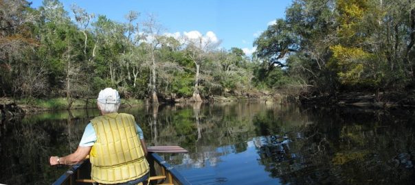
It has been 25 years since we paddled this river, which I had remembered  was similar to the Blackwater River at Collier Seminole, wrong. Lots of Houses, docks, power boats and it is not a scenic trip. We did see a Manatee, Heron’s, Egrets and Vultures. The only good thing was that it was not a weekend when all kinds of canoe/kayak livery paddlers would be all over the river, we saw a few as we returned, The bad part, as you got past the docks and Manatee zones all the powerboats flew past us at full throttle. You would think they would have a little respect for 2 old people in an open canoe. Four clowns on Jet Skis almost ran right into us and each other. We did make it to the bay but decided to paddle back to camp  rather than risk going the short distance in the bay to the island. Our advise, find some more scenic place to paddle.


Koreshan Planetary CourtWhat is Koreshan Park about anyway? It is a historical site donated to the state in 1961 by a small communal religious settlement which started here in 1894. They conduct daily tours. Lots of tourists just come to visit the settlement which has been beautifully restored and worth the stop to discover how this small sect, similar to the Shakers, survived and thrived in the hot, jungle environment.


Walking/biking paths are all through the settlement which is well separated from the campground and canoe livery.

On Wednesday morning we will head back to Lithia Springs Park which is close to Tampa.


Click for trip plans and map

Back at Lithia Springs for another week or so

Alafia RiverWe got here about noon on Wednesday. We were surprised to find that only a few campsites were available. But, luckily we got the same site that we were in last month. Which is right across the camp ground road from the river. When we left Estero it did not rain but we were happy that they got 3/4” rain last night before we got here. The river has been running on the low side all winter due to lack of rain in FL. I checked the USGS gauge and the river had already come up from 80 to 100 CFS, we hoped that by Thursday it would come up even more. Now we needed to find a way to get our canoe to the Alderman’s Ford  to launch on Thursday.

So I biked around the campground and found a couple with a canoe on their pickup truck. They are paddlers from NC and were planning on paddling the river on Friday but offered to drop us and our canoe off at the put-in on Thursday morning, if I would bring their truck back from the put-in to the take-out on Friday. Of course I jumped at the deal and luckily for us the level came up to 130 CFS.

Alafia River Take-Out

Last year we paddled the river twice, both times near 300 CFS, which made the 9.5 mile run much faster. But todays level was high enough that we never touched a rock even running over the 6-7 shallow class I rapids.  With our rest stop at Duck Landing it took us just over 3 hours. The river dropped to 100 CFS for our new friends run on Friday and they said it was passable but in their light weight Kevlar canoe they would not have wanted to paddle it any lower.

Feral HogsIt was cool, low 70’s, but we still saw 3 gators, some feral hogs and a site we never saw before. A large Heron caught a big snake and when we went by he took off with the big snake dangling from his beak. I hope he shared it with his family.


FishHawkTrails9_thumb2

The other reason we like this campground is that there is access to the miles of concrete trails, shown in orange on the map, that go through all the natural areas of this huge housing development called Fish Hawk Ranch. Click for bigger picture.

The park has a bike/hike trail that runs near the river but it is for hardier souls.

We biked about 8 miles on Friday and about 10 miles on Sunday and went in two totally different areas. Not counting the sidewalks along the streets there has to be at least 25 miles of trails along the retention ponds and wild areas.

We were looking for a mailbox to mail our grandson Jeffery’s birthday card. No mail boxes or post office at all, we mailed it back at our campground.

Silver Lake Again

Canoeing_Withlacoochee_w

2017 FL Map5 We just arrived at the Silver Lake campground complex and have again decided to stay in Cypress Glen Campground. We didn’t get the exact campsite that we wanted but we got the one next to it and it is only a few yards further from the canoe launch area.

As I told about this in older blogs there are several reasons to stop at the campground. It’s easy to get to, right off I-75. Not many people know about it, since it is a State Forest and not widely advertised and they don’t take reservations. It has 30/50 amp power & water at two of the 3 campgrounds. It is on a lake that is really a wide spot on the Withlacoochee South river. You can paddle up and down the river from here and if you want to just paddle downstream, you can arrange a shuttle at a canoe livery or just spot your vehicle at the take-out and bike, on the parallel bike trail, back to the camp to start your trip.

And for bicyclists, the camp is only 1 mile off the the 46 mile long Withlacoochee State Trail, one of the longest paved bike trails in FL.

We are starting to think about home and the route we may take North. Our plan is to stay here for five nights and then, on Saturday, go visit Helen & Paul who live just a few miles away in Inverness. We were going to visit them in December but it didn’t work out. We met them in Mexico where we all camped at Xpu-Ha in 2013-14.

We noticed that the campsites at Juniper Springs in Ocala National Forest are reserved on most weekends so we plan to arrive on Sunday morning when the weekenders leave.

We skipped the Okefenokee this year when heading south so we hope to paddle there as we head more north in early March. Our plan is to enjoy the back roads of Florida and Georgia and avoid the interstate highways as much as possible.